3D MODELING & DIGITAL TWINS
Create accurate, survey-grade 3D models of your construction sites, buildings, and infrastructure. BIM-ready point clouds and digital twins for design validation and as-built documentation.
Get a Modeling QuoteProfessional 3D Photogrammetry for Construction
Transform physical assets into detailed, measurable digital replicas using advanced drone photogrammetry. Our 3D models integrate seamlessly into your existing BIM workflows, design software, and project documentation processes.
Validate Designs Against Reality
Compare as-built conditions against original design plans to ensure accuracy and identify discrepancies early. 3D models reveal what two-dimensional drawings cannot.
BIM-Ready Deliverables
Generate survey-grade point clouds and mesh models in LAS, LAZ, OBJ, and FBX formats. Import directly into Revit, ArchiCAD, Civil 3D, and other BIM platforms.
Immersive Documentation
Create interactive 3D visualizations for stakeholder presentations, virtual site tours, marketing materials, and regulatory compliance documentation.
RTK-Enabled Precision Capture
Using RTK-enabled drones and precision ground control points, we deliver 3D models with the level of accuracy required for engineering and architectural applications. Every point in our models is georeferenced and dimensionally accurate.
- Orthomosaic Maps (2D aerial imagery with geo-coordinates)
- Digital Surface Models (DSM) & Digital Terrain Models (DTM)
- 3D Point Clouds (.LAS, .LAZ formats)
- Textured 3D Mesh Models (.OBJ, .FBX, .ply)
- Contour Maps and slope analysis
- Cross-section profiles for design comparison
Typical accuracy: +/- 2-5cm at ground level, suitable for engineering calculations and compliance documentation.
Request a Data Format Consultation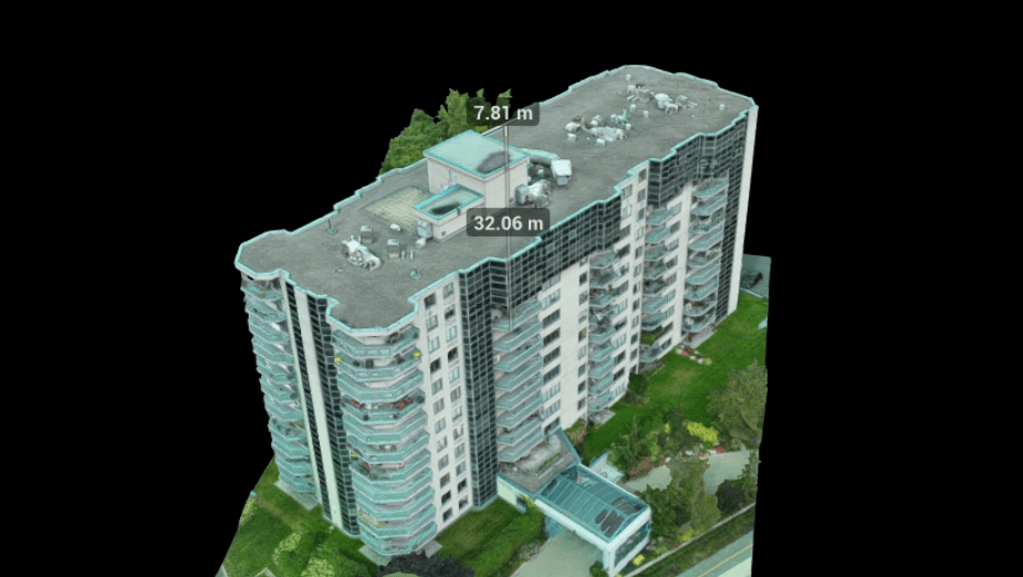
Who Uses 3D Models?
Our photogrammetry services support workflows across multiple industries and project types.
Construction Progress Tracking
Create time-series 3D models to visualize structural progress, compare periods month-to-month, and identify schedule delays before they compound. Digital twins enable what-if analysis for project planning.
Civil Engineering & Site Development
Capture as-built conditions for earthworks, road design, and land development. 3D models generate volumetric data and cross-sections for engineering analysis and cost estimation.
Heritage & Building Documentation
Document historic structures in detail before renovation or repair. 3D models serve as legal records for insurance, compliance audits (including Loi 122 facade inspections), and future reference.
Asset Inventory & Facility Management
Create digital twins of properties for facilities teams, maintenance planning, and insurance documentation. 3D models reduce on-site measurement time by 70%.
Client Presentations & Marketing
Visualize projects for investors, contractors, and stakeholders using interactive 3D tours. Models convey scale and complexity far better than static photos or traditional CAD renderings.
Quantity Takeoff & Cost Estimation
Extract precise measurements directly from 3D models for material quantities, surface areas, and volume calculations. Reduces estimation errors and supports competitive bidding.
Drones vs. Traditional Survey Methods
Traditional land surveys and laser scanning are slower, more expensive, and less comprehensive than drone-based 3D modeling.
| Factor | Traditional Survey | Drone Photogrammetry |
|---|---|---|
| Cost | $8,000 - $25,000+ | $3,000 - $10,000 |
| Time to Complete | 1-2 weeks | 2-3 days |
| Site Disruption | High (multiple visits, survey crew on site) | Minimal (single 2-4 hour flight) |
| Coverage Area | Limited by crew capacity (1-2 hectares/day) | Unlimited (100+ hectares in single flight) |
| 3D Visualization | Point clouds or static contour maps | Textured 3D mesh + orthomosaic + point cloud |
| Accessibility | Cannot access dangerous or remote areas safely | Captures inaccessible terrain and structures |
| BIM Integration | Manual conversion required | Direct export to .LAS, .FBX, .OBJ formats |
Why 3D Models Save Money
The investment in drone photogrammetry returns value through faster project planning, reduced measurement errors, and better stakeholder communication.
Real-World Example: 50-Hectare Site Development
- Traditional Survey Cost: $18,000 + 10 days
- Drone Photogrammetry Cost: $6,500 + 2 days
- Immediate Savings: $11,500 + 8 days faster to design phase
- Additional Value: Complete visual documentation reduces change orders by 15% (roughly $25,000 on a $1.5M project)
- Total 1st-Year ROI: $36,500
Faster data capture + Better stakeholder alignment = Fewer errors and change orders. Even on small projects, 3D models pay for themselves.
Frequently Asked Questions
Everything you need to know about 3D modeling and photogrammetry.
A point cloud is a 3D collection of individual data points (millions of them), each with X, Y, Z coordinates. It's sparse but highly accurate. A mesh model is a continuous surface created by connecting those points into triangular faces, creating a smooth 3D surface you can visualize and navigate. For engineering analysis, point clouds are preferred. For presentations and BIM integration, mesh models are ideal. We provide both.
Yes. We export point clouds in LAS/LAZ format and mesh models in OBJ and FBX formats, which are compatible with Revit, ArchiCAD, SketchUp, Civil 3D, and other industry-standard BIM platforms. We can also provide the data in other formats if your workflow requires it. Many of our clients use our point clouds as base geometry for BIM model creation.
Using RTK-enabled drones and ground control points, our models achieve +/- 2 to 5cm accuracy at ground level. This is survey-grade accuracy suitable for engineering calculations. Accuracy depends on image overlap, flight altitude, and ground control point distribution. We discuss accuracy requirements during the consultation phase and adjust our methodology accordingly.
Flight capture takes 2 to 4 hours depending on site size. Processing and model generation typically takes 2 to 5 business days. We deliver preliminary results quickly for time-sensitive projects, with full deliverables within 1 week. Rush processing available with additional fees.
Yes. Overcast conditions are actually ideal for photogrammetry because they eliminate harsh shadows. Snow coverage may obscure ground features but doesn't prevent data capture. We don't fly in heavy rain or strong winds. Winter operations require no additional cost and often deliver superior results.
Yes. Orthomosaics are 2D geographically-referenced aerial maps created from the same imagery as the 3D model. They're extremely useful for basemaps, construction planning, and progress documentation. Every 3D modeling project includes orthomosaics as standard.
Yes. We deliver all data via your choice of cloud storage (Google Drive, Dropbox, OneDrive, AWS) or physical hard drive. File sizes can be large (5-50GB depending on project), so discuss delivery preferences during your initial consultation.
Transform Your Project into a Digital Asset
Contact our team today to discuss 3D modeling for your construction, engineering, or property documentation needs.
Request a Modeling Quote