VOLUMETRIC CALCULATIONS & STOCKPILE MEASUREMENT
Measure stockpiles, earthworks, and construction materials with unparalleled speed and 99% accuracy using drone photogrammetry. Fast, safe, reliable inventory and project data.
Get a Measurement QuoteData-Driven Inventory & Cost Control
Inaccurate material estimates lead to budget overruns, project delays, and contractor disputes. Our drone-based volumetric calculations provide precise, auditable data that supports competitive bidding, inventory tracking, and project reconciliation.
Manage Inventory Precisely
Get exact volume and tonnage data for any stockpile: gravel, sand, soil, aggregates, wood chips, ore, and more. Reduce shrinkage losses and optimize purchasing decisions.
Improve Project Bidding
Create competitive, accurate bids with precise measurements of cut and fill requirements. Win more bids by eliminating cost uncertainty and demonstrating precision to clients.
Simplify Reconciliation
Track material moved over time and verify contractor work with regular, documented drone surveys. Reduce disputes and support project cost control.
Manual Stockpile Measurement vs. Drone Surveys
Traditional ground surveys of stockpiles are dangerous, time-consuming, and interrupt site operations. Here's how drones transform the process:
| Measurement Method | Manual Survey | Drone Volumetric |
|---|---|---|
| Safety Risk | High (personnel climb unstable stockpiles) | Zero (ground-based operation) |
| Time Required | 2-4 hours per stockpile | 30-60 minutes for multiple stockpiles |
| Accuracy | 75-85% (prone to human error) | 99% (photogrammetry-based) |
| Documentation | Written notes, sketches | High-res photos, 3D model, precise coordinates |
| Historical Tracking | Limited repeatability | Perfect repeat flights for period comparisons |
How We Calculate Volume
We use advanced photogrammetry to process drone imagery into precise 3D point clouds and terrain models. Every cubic meter is calculated from actual spatial data, not estimates.
- High-resolution orthomosaic maps showing stockpile boundaries
- 3D point cloud with sub-centimeter accuracy
- Digital terrain model (DTM) for pit/foundation depth
- Volumetric calculations with margin of error analysis
- Tonnage estimates based on material density
- Geographic coordinates for inventory tracking
Typical accuracy: +/- 2% volume error compared to ground truth measurements.
Schedule a Free Site Assessment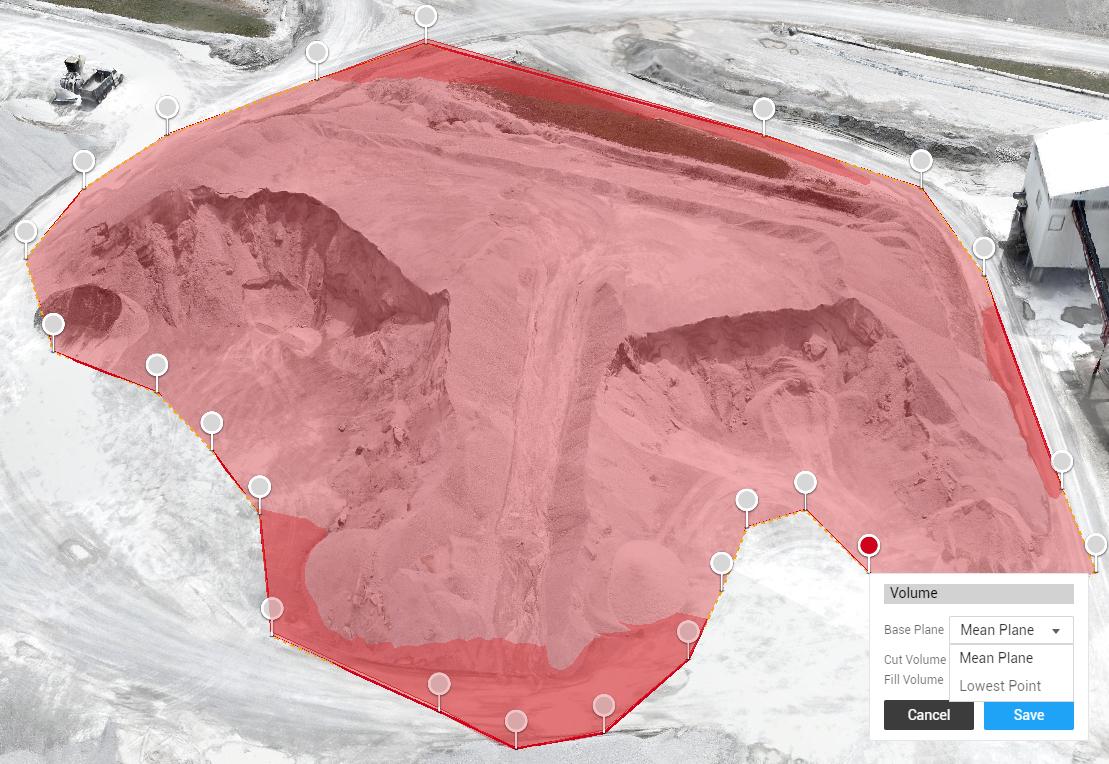
Who Uses Volumetric Data?
Drone-based volumetric calculations support operations across construction, mining, aggregates, forestry, and waste management.
Construction & Excavation
Track earthworks progress, verify cut and fill volumes, and support contractor reconciliation. Essential for cost control on large projects.
Aggregates & Mining
Monitor stockpile inventory, track material movement, and support production planning. Accurate measurements prevent overstocking and supply shortages.
Forestry & Timber Operations
Measure log volumes and biomass. Drone surveys provide repeatable measurements for inventory control and sales documentation.
Waste Management & Landfills
Track waste volume, monitor landfill capacity, and support regulatory compliance reporting.
Contractor Verification
Independent volumetric surveys verify contractor-reported quantities. Settles disputes and supports project invoicing.
Insurance & Claims
Document material loss, damage claims, and supply theft with unbiased drone-based measurements.
Why Accurate Measurements Save Money
The cost of a drone volumetric survey is typically recovered within weeks through better inventory control, reduced waste, and avoided disputes.
Real-World Example: Gravel Pit Operation
- Manual Survey Cost: $1,200 (labour) + inaccuracy losses
- Drone Volumetric Cost: $2,800
- Story: Manual surveys had 12% error margin, leading to $8,500/month in inventory mismanagement
- Result: Drone survey identified actual inventory was 340 tons lower than reported
- Immediate Savings: Prevented overshipment, avoided stock shortage
- ROI Breakeven: First survey pays for itself in ~2 weeks of corrected ordering
One inaccurate shipment, one missed bid, one inventory error—and your drone survey has paid for itself.
Frequently Asked Questions
Everything you need to know about volumetric calculations and drone surveys.
Drone-based volumetric calculations achieve +/- 2-5% accuracy, typically better than traditional ground surveys (75-85% accurate). The accuracy depends on image resolution, overlap, flight altitude, and ground control points. We discuss accuracy requirements and any margin of error in your report.
Yes. Our photogrammetry methodology captures the exact 3D surface, including overhangs, slopes, and irregular edges. The 3D point cloud represents actual geometry, not simplified assumptions. This is why drone surveys are more accurate than manual measurements for complex stockpile shapes.
We measure volume from the 3D model and you provide the material density (e.g., 1.6 tons/cubic meter for gravel). We multiply volume by density to calculate tonnage. Different material types have different densities, so we ensure you specify materials accurately. We can also provide density ranges if needed.
Yes. Independent drone surveys provide unbiased volumetric data and are commonly used for contractor verification. If there's a discrepancy between contractor reports and our measurements, we provide detailed documentation supporting our findings. This is useful for contract reconciliation.
Frequency depends on your operation. High-volume material flows may warrant weekly surveys. Lower-volume sites might need monthly or quarterly surveys. Many clients establish a baseline survey, then conduct periodic surveys to track changes. We recommend discussing your operational cadence during initial consultation.
Yes. All volumetric surveys include the 3D point cloud and orthomosaic map used for calculations. You can visualize the stockpile in detail, measure specific points, and compare historical surveys. Learn more about our 3D modeling services.
We deliver volumetric reports in PDF format, plus the 3D data in LAS/LAZ (point cloud) and OBJ (mesh model) formats. All deliverables are georeferenced so you can import them into GIS, CAD, or other analysis software. Raw imagery and orthomosaics also included.
Know Exactly What You Have On Site
Stop relying on estimates. Get fast, accurate, and safe stockpile measurements for inventory control and project management.
Request a Measurement Quote